Lima from beginning to end
...Or however you describe a round trip around Lima. Clara arrived at the hotel at 6 a.m. and after a small breakfast we set off to explore the city
From San Isidro we walked through the barrios towards the Centro Histórico. We walked the 5 km through the part of Lima where there aren't many tourists. In addition to many small stores, the Mercado Lobaton and the Castillo Rospigliosi, we also passed through various parks such as the Circuito Mágico del Agua or Parque de la Exposición.

In addition to lots of traffic, there were also plenty of roadworks. When we arrived at Plaza José de San Martín, we were standing in front of the Centro Histórico.

For the first 30 minutes, I felt like I was in a pedestrian zone. It wasn't until we reached the Plaza Mayor de Lima that the historical buildings really began to appear. But apart from the Basílica Catedral de Lima, the Basílica y Convento de San Francisco de Lima and the Convento Máximo de Nuestra Señora del Rosario, the rest looked like administrative buildings, such as the Palacio de Gobierno de la República del Perú. The streets sold everything from Pisco and chocolate to jewelry and alpaca clothing. In between are cafés and restaurants. From cheap to exclusive!

After 6 hours on foot, we had had enough. I wasn't really impressed by this part of Lima. Let's see what else there is to discover in Lima at the end of Clara's visit.

The next morning, 1 hour on the streets of Lima until we were able to go shopping in a Tottus in the north along the Ruta 1N. The MegaPlaza is a huge complex and you can get pretty much anything here apart from food. Only vegan products, such as tofu or vegan cheese, were not available.
Most of the malls or shopping centers along the 1N had no height restrictions and parking was no problem. But the traffic routing was a bit of an adventure.
We headed north along the Ruta 1N, more precisely to the Complejo Arqueológico Caral. Similar to the Ruta 1S, it was hazy and there was almost no visibility. It was only on the last few kilometers, past huge tents, that visibility improved. We later found out that the tents were chicken coops. There are so many of them along the coast, but there is relatively little smell of chicken droppings.

Caral lies in a desert-like landscape and only the Rio Supe brought some green into the picture.
Caral is the oldest city found in Peru and South America (more than 3'000 years BC) and the seat of the first Andean civilization. Together with Mesopotamia and Egypt, it is one of the oldest cultural centers in the world.

The builders of this complex were the Caral people. Although the pyramids are not as large as those in Egypt, they are still impressive today.
The city was built on the banks of the Rio Supe on a large terrace of around 65 hectares. In the past, up to 3'000 inhabitants lived in the city and water and food were brought into the city from the Rio Supe valley.

Without a guide, you are not allowed to move around the excavation site and our tour lasted about 1 hour. My Spanish wasn't really good enough to understand everything, but our guide made a real effort.
The next day, we drove along Ruta 16 from the Pacific Ocean up to over 4'100 meters above sea level. We acclimatized not far from Laguna Conococha. We had actually wanted to spend the night below 3'000 m, but none of the pitches appealed to us.

It was a restless night. Firstly because the truck traffic on the Ruta 16 didn't stop during the night and secondly because Clara was suffering from altitude sickness. But the next morning it was better and we decided to take a rest day at Laguna Tapara. Far from the Ruta 3N, we enjoyed the panorama and the bird life at the lagoon.

Like the days before, the weather turned bad in the afternoon and was set to stay that way for the next few days. So hiking was the order of the day in the morning. I baked bread again, which didn't rise despite the new yeast from Germany.
The descent along the Ruta 3N to Huaraz ran through a beautiful Andean region along the Rio Santa. Although the road is not in the best condition, the view makes up for everything.
Huaraz is nestled between the mountains and is the starting point for hikes in the Parque Nacional Huascarán.

The first thing I liked was that we found a parking space in the middle of the town. We were able to shop in organic markets and also got vegan products. The Mercado Central de Huaraz offered fruit, vegetables and tofu for little money.
I was impressed that the sellers openly told us that the branded goods were not genuine, but were much cheaper. I hadn't seen any big differences in the quality of the quilted jackets.
We spent the evening at the only camper van campsite around Huaraz, Marian Whai. We were lucky, because two weeks earlier a landslide had cut off the water supply to the area. The owner, Avencio, lived on site and opened the gate. As my Spanish isn't the best, he showed us that the water wasn't working and, surprise surprise, it worked again. So we got a nice warm shower after all.
The last few days it had always rained from 15:00 onwards. That's why we wanted to go on a hike nearby the next day. In Carhuaz, we headed up into the mountains. Along the slope, children charged a kind of fee at the entrance to the village. Even the restaurants paid one soles. In Hualcan, we set off into the mountain forest. Our destination was the Shonquil Pampa and the slopes of Chiqllarahu and Wallqan. We had already seen the mighty Nevado Huascarán Sur on the way, but it was hidden in the clouds as we hiked.
The Parque Nacional Huascarán is famous for its lagoons and the striking, snow-capped mountains. Laguna 513 was close to us, but at 4'460 m.a.s.l it was not feasible for us.
So on this first day we hiked almost 12 km at an altitude of over 3'100 m.a.s.l. It became a few meters more, because the “bridge” at the gate to Shonquil Pampa did not exist and we were very nervous whether the 2nd bridge at Hualcan existed. We were lucky, the 2nd bridge did exist and we reached the motorhome before the rain started on time.

We then drove into the Parque Nacional Huascarán via the Ruta 107 and through Shilla. Shilla looks quite normal on Google Maps, but the road through the town is bizarre. The straight road goes up the hill at 50% and at the top end the road is narrowed by two concrete bollards. With a bit of tact, the Dog.O.Mobil got through after a few minutes. Otherwise we would have had to reverse back down the steep slope.
We wanted to spend the night at the foot of Punta Olímpica that evening, but the sandy spot was impassable in the constant rain. So we climbed up the serpentines to the tunnel at Punta Olímpica. At first it was just fog and rain, but halfway up the road we were met with snow and freezing temperatures.

After a 30-minute drive, we were at the eastern exit of the tunnel at 4'460 meters. Zero visibility, driving snow and no usable parking space. Along the descent to Chacas, we then found a pitch on a stony meadow at 3'600 m, a little off the Ruta 107.

It wasn't going to be a quiet night, as there was a knock at the door at around 23:30. A Peruvian man with a flashlight needed help. It was only when I went with him to his car that I saw the problem. He had got his right tire into the 40 x 40 cm water channel. To cut a long story short, I got my tow rope, a bus stopped and we filled the gully with stones. He was out at the second attempt.
The next day, we continued on the R107 towards Chacas. The landscape in the sunny daylight is beautiful. A narrow river valley, greenish slopes and snow-covered mountains or glacier edges.
In Chacas you can still find well-preserved buildings from the 17th century, the Spanish colonial era. The buildings could have been built in Spain. We saw houses with carved balconies and gates along narrow streets and the Plaza Mayor de Chacas.

The R107 then slowly winds its way down the mountains to Acochaca. Clara said it looks like the Black Forest here, a high Black Forest! Except that there were far more slippery slopes here than in the Black Forest. But that didn't bother anyone here as long as you could get through by car or truck.
From Acochaca on-wards, the paved R107 turned into a dirt road of initially passable, later mixed quality. As usual in Peru, driving through towns was the biggest challenge. Open manhole covers, deep potholes and in San Luis there were gradients of well over 50%. We didn't just touch down once.

The closer we got to the Embarcadero Huachucocha and the Capilla Ugo de Censi, the better the road became and we crossed the tree line.
The Capilla Ugo de Censi is located at around 4'300 meters above sea level and offers a fantastic view of the region and the tectonics. The approx. 80 m climb from the Ruta to the Capilla is well worth it. In the distance, the peaks of Qupa and Wallqan could be seen in the sunshine. It was to be the first day without rain.

The road was good as far as Huamparan and we were able to drive at 40 km/h in places. The road to Huamparan was adventurous. The houses in the villages were often painted white for the upcoming election of the Alcalten and covered in red or green with election slogans. There weren't many cars on the road and only occasionally could you see people working in the sun.

We continued to Acopalca at a maximum speed of 20 km/h and in Acopalca we turned off to Laguna Purhuay. We climbed 500 meters in altitude over 5 km on a narrow track on a steep slope. I was glad to park at the top of the lagoon after 30 minutes.

The lagoon is nestled in green mountains. There were two small restaurants where you could eat delicious fish from the lake and the 2 owners of the restaurants had no problem with us spending the night here. During a short tour of the van and explanation of the flags, we had a long conversation in Spanish.
Apart from the barking of the dogs, the night was pleasant.

The day's stage was to take us to the next laguna, Laguna Conteycocha. It was the road and the campsite rather than the laguna that drove us on that day. We headed downhill along the Ruta 14B and Ruta 14A to San Marcos. The road was OK and the landscape east of the Parque Nacional Huascarán was once again breathtaking.

However, Google Maps wanted to present us with a highlight on this day. Instead of letting us turn off onto the Ruta 111 in San Marcos, we stayed on the Ruta 110 to Quercos and only here did we turn off onto a better dirt road that went into the mountains via Challhuayaco. The road through Challhuayaco was bad, really bad. But we drove on. Over the next few kilometers, I occasionally doubted whether the route was too tough. I only drive a Sprinter 2WD, which is 7 meters long
In Huayronga the road got a little better, but after a few kilometers the serpentines started. Easy bends at first and then steep and tight bends further up, which really pushed the Dog.O.Mobil and me to the limit.

At one point I had to back up and Clara had to show me the way. Behind the Sprinter we went down 300 m, in front of us we went up the bend at 50% and on the right was a 40 cm deep concrete ditch. But we managed that too! And so it went on until we reached Togacruz (approx. 4'300 m.a.s.l ) and the highest point of the day's stage.

After another 5 km, we reached the perfectly paved Ruta 111 and turned off onto Ruta 3N. Our campsite at Laguna Conteycocha was ok and it was enough for a short walk.

If the day was already challenging, the next day's stage to Huánuco was a different kind of challenge. The 160 km along the Ruta 3N should have taken 3 hours, but took almost 5 hours, as the route was a series of mountain slides. We joked during the day whether we would manage to ride a kilometer without a landslide. I would say that we had bits and pieces, as the construction sites with landslides were longer than 2 km.

At the end of the day, we were really exhausted when we stopped at a hotel in Coar Huánuco in the afternoon and enjoyed a hot shower. There were relatively few campsites in the whole region and even fewer that had a hot shower.
The next morning we shopped larger at a Tottus in Huánuco. In my opinion, there are only 2 large supermarket chains in Peru. One is Tottus and the other is plazaVea, which you can find in the larger towns.
A lot of fruit and vegetables had gone bad after 2 or 3 days and we also needed a few basic things that you couldn't necessarily get in the small stores along the street.
We had tried roasted corn and lupins before, which were really tasty, but the salad, a ceviche de chochos, was really great.
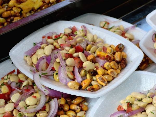
This simple salad was freshly prepared on the roadside and sold in a plastic bag with a plastic spoon for a mere 1.5 soles (€0.37). The chocho is rich in protein, "vegan & gluten-free" and is easy to make, as it only consists of
- Tarwi (Peruvian lupin), seeded and cooked
- Onion
- Lemons
- Coriander
- Rocoto chilies
- fresh Tomato
- Olive oil to taste
- Salt and pepper to taste
Here is a recipe -> Cómo preparar Ceviche de Chochos o Tarwi 😋 Fácil, Exquisito y Nutritivo /Comida peruana
The Peruvian national salad, the Ensalada de Choclo con Queso, is not for vegans,
:quality(75)/cloudfront-us-east-1.images.arcpublishing.com/elcomercio/4EQBSZIIONFJ7KCJ7T4NU7V23M.jpg)
But there is this variant for vegans: Ensalada de porotos negros con choclo y pimientos asados
Huánuco was only 1'800 meters above sea level, but between here and Lima was the Cordillera de la Viuda

The difference in altitude between Lima (sea level) or Huánuco and the Cordillera de la Viuda (around 4'700 m.a.s.l.) is considerable. Altitude sickness was a real problem for Clara, even after 1.5 weeks in the mountains. We hiked to 3'200 - 3'500 m near Huaraz and spent the night at 3'900 m, but at the height of Laguna Angascancha we started to suffer from headaches and nausea.

At the Bosque de Piedras de Huayllay, it was only enough for a photo stop. From there, we went further up to the plateau and continued for another 70 km at an altitude of over 4'000 meters. In addition to beautiful lagoons, e.g. Laguna Huancaccocha and mountain panoramas, we continued on a perfectly developed and paved Ruta 20A towards Lima. Only at Cullhuay did we get below 4'000 m, but then it went rapidly downhill. Unfortunately, there are not many campsites in this narrow day and the few that are available are right next to the Ruta 20A

After a night next to the Ruta 20A, we packed up and needed almost 3 hours for the 100 km to Lima. From C.P Punchauca onwards, the traffic was heavy, loud and smelly. I followed buses, because the Dog.O.Mobil should be able to fit through where the 2.6 m wide buses could. I learned to honk my horn prophylactically, as Peruvians do. I ignored traffic signs and made my way to the parking lot.
There were 2 designated parking spaces in Lima on IOverlander.com. The first was closed and we were lucky with the second. It wasn't cheap, 20 USD for the day, but it was guarded 24 hours a day and there was room for us. The contact was Jose Luiz, WhatsApp: +51 931683140.

We spent the next few days sightseeing, eating out (vegan) mainly between Miraflores and San Isidro and trying different types of Pisco cocktails,

We also treated ourselves to a cooking course with a visit to the market. Mercado No. 2 Surquillo is a market for Peruvians and there weren't many tourists around. The variety of fruit and vegetables was impressive.

We cooked 3 starters and 3 main courses with 7 people. Vegan was no problem. Haku Tours had organized it well


I would say that the second stop in Lima, or Miraflores, fully made up for the disappointing impression of the Lima Centro Histórico.

The Stage

More Pictures
Videos
Latest Posts
-
 Closer to the end - South Colombia till Medellin
 -
 Ecuador - La Balsa to Tulcan
 -
 Lima to Ecuador
 -
 Lima from beginning to end
 -
 Cuzco to Lima
 -
 From Lake Titicaca to Cuzco
 -
 Bolivia, in search of diesel


Post Info
Date | Mai 2025 |
Status | Done / Visited |
Last updated | 03 October 2025 |
Page read | 575 |